I love New Zealand

Mt. Cook Map

Haven’t actually been there, but I am planning to go next year, only fair since they’ve named a mountain after me ;). Linz (Land Information New Zealand) just released a new series of 1:50k today, so I headed over expecting it part with a fair amount of cash to buy all the maps I needed to walk the 1800 mile Te Araroa. Much to my delight you can download them all for free!

Good work New Zealand, I only wish more countries would make their maps available for free :)

Away for a week and a half

Away for a week and a half

No blog updates for a few days, going up to the lakes for a wedding. But after that me & Nicky plan to climb Scarfell Pike, Snowdon and Ben Nevis (in that order) before another wedding in Scotland the following weekend. So we’ll probably post a few pics of our progress to keep you going. If you’re not aware, those are the highest mountains in England, Wales and Scotland. The thing to do is try and climb them all in 24 hours, but we’re not doing that…

Above is the making of my first ever wedding cake, may well be my first ever cake for that matter… The cake was pretty easy, but the marzipan is proving to be more difficult than I had imagined to work with. I’ll not spoil the surprise by showing the finished cake, will post it after the wedding.

Switzerland Holiday Video

I‘m in the process of editing the video of our Swiss walk. I’ll not bore you with the whole thing, but here’s the intro. We had probably the worst weather I’ve ever had on a walking holiday, but when it wasn’t raining there was a few days of glorious sunshine. The intro reflects these two opposite experiences, starting off with all the bad stuff, then as the song changes, so does the weather and all is good :)

Set ot the beat of – Freedom Rock / Mister Freedom by Serge Gainsbourg.

Beef Club

Beef Club - Zurich

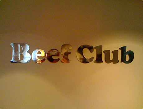
I thought we’d already had our big ‘end of walk steak’, but then in the afternoon we walked past – Beef Club! Some friends of ours run a regular social gathering in London called Meat Club, all dressed up in butchers outfits and eating nothing but meat. I was expecting much of the same, sadly but unsurprisingly Beef Club was more of a Gentlemens Club than a Meat Club.

I liked that on the menu, the small steak was called Business Cut, but the large steak was Gentleman’s Cut :)

Beef Club - flambéed with Cognac

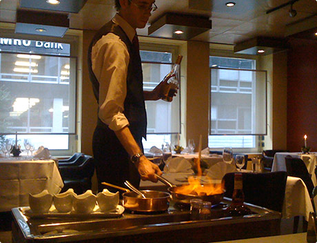
Me & Nicky both share a burning passion for food that arrives on fire, so there was no choice really when with we saw Swiss Prime beef tenderlion, flambéed with Cognac on the menu. The waiter wasn’t shy with the booze and got a good old fire going on!

Beef Club - John Bull Pepper Steak

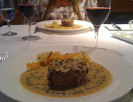
The dish was called John Bull’s Peppersteak, if you don’t know who John bull is, check this picture here. He’s the British equiliant of the American Uncle Sam and is quite a portly fella. Not sure if this portion would of even touched his sides, I certainly could of easily seen away two of them. Damn tastey though, I’m not knocking it!

Beef Club - Crêpe Suzette

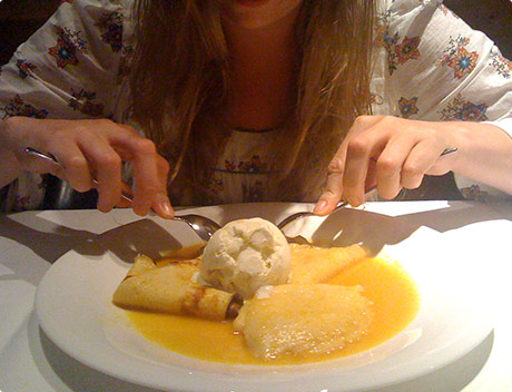
In honor of her Dad, who apparently loves the flamming Crêpe Suzette, Nicky had it for pud. Two flamming dishes in one meal, that doesn’t happen every day. I had an ice cream from what was the most extensive ice cream menu I’ve ever seen, 20 odd pages!

Zürich

Zurich canal

Well I must say that Zürich exceeded my expectations, what a beautiful city! The thing I couldn’t believe was how clear the water was there? The river going through the city centre is crystal clear and an amazing shade of bluey green.

This here is a snap of a canal we passed with a canoe assault on it. Look at that water, made me just want to jump straight in! I’ve lived by Regent’s Canal for many years in London and never felt the urge to get my feet wet in that!

Zurich canal with a swan

Swiss Alps here we come

Route across the Swiss Alps

Me & Nicky are off on holiday today, going to be walking across Switzerland, mainly follow the Bernese Oberland Range. Should be amazing, really need 2 weeks off in the mountains to unwind from a hectic project..

Sadly the weather forecast in rain, rain, thunderstorms, more rain and a bit of snow.. Oh well should make for a few interesting stories, I will keep the blog updated with our progress.

For those interested you can see our proposed route here.

Alpine Pass Route

Alpine Pass Route

Probably the most common questioned I get asked is – what have you got planned for your next walk? Well I’ve booked some cheap flight to Switzerland (£40 return, can you believe that? – Aer Lingus), ordered some maps and have been planning the route all weekend :) Click the image for a bigger map of our planned route.

I haven’t been to the Alps since ’95 (I used to go just about every year) so it’s about time for a visit. I’ve been keeping my eye on a new series of long distance trails crossing the Alps called Via Alpina. They just updated their site with lots more info on the routes and handy download-able section pdfs. There’s 5 trails in all, the daddy being the Red Route which is 1500 miles. Also found the site of Judy Armstrong who did a loop mostly on the Via Alpina trails, crossing the Alps twice in a whooping 3,300 mile single season trip!

I’ve a picked a little section for me and Nicky across Switzerland (Bernese Alps), mostly on the Green route, but with a bit of the Red at the end. As well as being part of the Via Alpina, (most of) the route seems generally known as the Alpine Pass Route. I found a site – Activity Workshop, that has a lot of online information about the walk, they also plotted the route on google maps which I’ve found quite handy. Also there’s a Cicerone guide of the Alpine Pass Route, by the legendary Kev Reynolds.

Can’t wait till the end of June now, I’ll be blogging as we go as usual. Hopefully if Nicky enjoys herself, we might plan a full traverse of the Alps in 2010 :)

The Mighty Deerstalker

The Mighty Deerstalker

In a month’s time (21st March) it’s another of those eccentric and uniquely British events, The Mighty Deerstalker, held just south of Edinburgh, in and around the town of Innerleithen.

It’s an “adventure run” with a difference, all the racers are dressed up in tweed :) The Deerstalker is Fun Run meets Fell Race meets Hellrunner meets Tough Guy. You can expect water jumps, log balance bars, prickly tunnels and cargo nets over the 2 distance options of: 5 km (ish) and 10 km (and a bit).

  1. Check out the route »
  2. Enter here »
  3. Location »

I don’t think I’ll be able to make it up to Scotland for the 2009 event, but maybe next year, looks great :)

Cheers for the link okjerome.

First proper traverse of the Andes

Andes traverse photos

Holy crap someone’s actually done a 7,800 mile continuous traverse of the Andes! I’m sure you’re aware of it’s status as the longest mountain range in the world, because of this I’ve dreamed of doing it (along with Everest of course) since I was a kid. I’ve looked into it many times for reference, but all I could find were stories of people who walked the length of South America, on roads… I wanted to find a story of someone had actually walked the length of the mountain range, not the continent.

At last I’ve found it (almost a year after they completed it though)Deia Schlosberg (28) and Gregg Treinish (26) managed to do what I wasn’t even sure was possible. Now I’m hungry to follow in their footsteps 2012 Paul?

andes map

I’m surprised that it only took them 2 years (665 days), I’d guesstimated it would probably be at least 3. Although if you look at their route, they seemed to missed a fairly big chunk at the top? Oh yeah, it’s Colombia, probably didn’t want to get shot ! Maybe there’s still time for me to be the first person to do it all :)

Not only were they the first people to backpack the Andes Mountain Range (walk it through the mountains without relying on roads), but also and Deia became the first woman to walk across South America.

Read their journal »
• See all their photos from the trip »
• Check out their video on YouTube »

Well my hat’s off to you guys, an amazing journey and thoroughly worthy of your best adventure of the year award.

Via: Best Hike.

CDT section planner / overview map / rough schedule

CDT Section Planner, overview map, rough schedule

Imade this map of the CDT split into each section with basic info like how far it was in between towns, what I thought our daily mileage would be based on the terrain and estimated date we’d be getting to each place. We found it incredibly useful to visualise an overview of the route ahead and get a quick mental summary of the next state etc.

I hope that someone planning their future CDT hike will find this post and find the maps useful. I’ve made 2 new version for you to download (both zipped files contain a jpeg & pdf version):

  • First map – with blank labels for you to print out and write in your eta.
  • Second map – with the our actual daily mileages and dates that we walked the CDT to use as reference. (I’ve fudged a few figures to make it more consistent). I would say that our pace was fairly ‘average’ our target was 20 miles a day, which seems to be most peoples target.

For more more info on our hike, see our ‘proof that we actually did it’ site here »

Oh and of course the base map is courtesy of Monsieur Google (his terrain view is kick-ass).