GR5 Topographic Maps

GR5

I’m off to the Alps this weekend with my brother to walk the GR5, 400 miles of mountains from Mont Blanc to the Med. They’ve had a record snow year over there (best in 50 years apparently), and we’re rather optimistically starting in June – should be quite interesting on some of the high passes..! I’ve been using the French Geo Portail site to stitch together some topo maps for trip, thought I’d post the finished map set to save someone else the bother :)

Get the maps:
Here’s a link to the Zip file to download (250mb).

It’s a PDF of 77 A4 maps to colour laser print (doesn’t bleed when wet like inkjet), I’ve mapped out most of the main alternative routes (GR55, GR52 etc) and some other variations that looked interesting. The orange line has mile markers along it to make it dead easy to gauge distances at a glance.

Te Araroa Trail Maps

Te Araroa Trail Maps

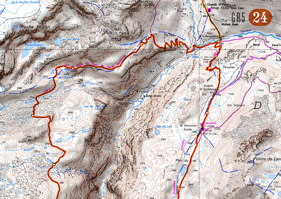
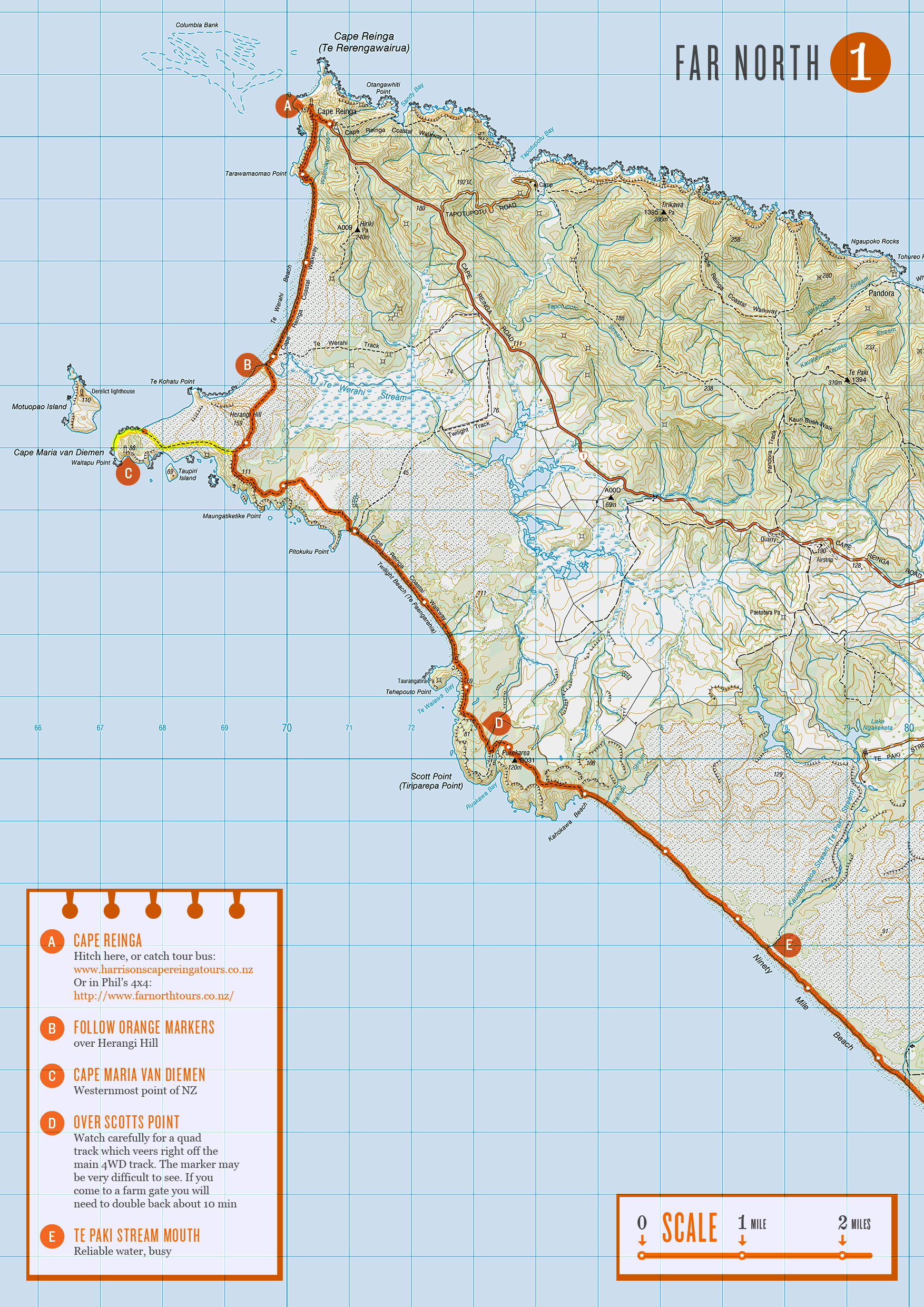
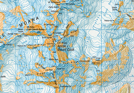
May not be of much interest to most, but if you’re planning on doing the Te Araroa trail in New Zealand, or just fancy having a closer look at what me and Nicky are going to be doing for the next 6 months, then here’s all the maps (268.4MB).

I can’t guarantee the route I’ve drawn on is accurate, the route itself is constantly changing, but also expect a fair amount of human error! If you use these maps follow your judgement and common sense, over the orange line. I didn’t get around to making all the map notes I’d of liked too.. but I’ve run out of time now and need to get on with other stuff. My plan is to check for the latest route descriptions and read people’s journals to find out info about the next section as we go and then doodle these notes onto my printed out maps. I’ve left a space on every page to be used for this purpose.

Info about the maps:

  • I made them A4 size for printing (ink-jet or laser)
  • They are all .gif format (small file size, no artifacting)
  • The route drawn on has little white dots every mile (can’t get my head round distances in KMs)
  • There’s 103 maps in total, so you’ll need 52 pieces of paper to print them all out (both sides)
  • Split into North Island and South Island folders, all numbered consecutively from north to south
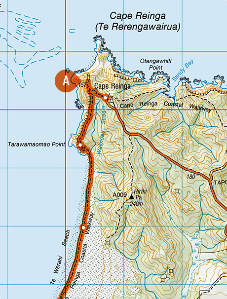
  • I’ve also done a total of 57 sheets of alternate routes, more on that later..

I always enjoy the pre-walk planning and mapping stage, although I’ve never bitten off anything even remotely as complex or long as this before (CDT maps were already done by Jonathan Ley). Got to say a big thank you to Land Information New Zealand who made all the 1:50,000 scale topographic maps and hats off to you for making them all freely downloadable :) The Te Araroa Trust for building the trail in the first place and providing all the route descriptions on their site. And most importantly to Geoff Chapple who founded the trust 16 years ago and who has been spearheading it’s development ever since.

When you’re following a pre-defined route, there’s always the temptation to work out a few variations that suit you’re own preference of terrain etc. While mapping the trail I managed to rack up more than I was expecting, 57 maps worth in total! I’ve got no idea how many, if any of these we’ll do, those sort of decisions usually make themselves at the time. But if you’re interested, these can be downloaded too (164.9MB).

Word of warning though – I’ve never been to New Zealand, so have absolutely no personal experience whether these are any good or not. I think they are all probably longer and more difficult than the official route.. But they do follow the same numbering as the official route maps (just with a ‘b’ after the number) so you can see where they fit into the trail.

If anyone other than me & Nicky end up using the maps, let me know how you get on!

I love New Zealand

Mt. Cook Map

Haven’t actually been there, but I am planning to go next year, only fair since they’ve named a mountain after me ;). Linz (Land Information New Zealand) just released a new series of 1:50k today, so I headed over expecting it part with a fair amount of cash to buy all the maps I needed to walk the 1800 mile Te Araroa. Much to my delight you can download them all for free!

Good work New Zealand, I only wish more countries would make their maps available for free :)

Your name & the internet

Personas

Up until today I wished I made a more unique name than Simon Cook, there’s shit loads of them out there! I could never get near the top of the google rankings, although I’m now slowly making my way up there, currently 5th :)

But I’ve seen 2 things today that made me happy that I’ve got loads of other namesakes. First up is this Personas site by Aaron Zinman from MIT it searches the internets for you and your namesakes and creates a visual aggregation of their online identities. I think the final result is a bit of a let down (I’m sure Jonathan Harris could do some much more interesting with the data). But watching the other Simon Cook’s and things they are up to flashing across the screen was quite fascinating.

Craig Robinson

Then I randomly went to see what Craig Robinson (Flip Flop Flyin’) was up to. He’s snapped up CraigRobinson.com when it became available, and rather than use it himself, he’s made a site linking up all the Craig Robinsons out there!

I love the idea, I think there should be a law that ‘name URLs’ should link up everyone that shares the name. I would definitely do the same if SimonCook.com ever became available.

Gridplane

Gridplane - Infographic

I was searching the web for infographic inspiration yesterday and stumbled across the work of JD Hooge on his site Gridplane. All his work is top notch, but I was particularly taken by his Data Visualisation project for Google. It’s just designs, no link to a working product, but hopefully Google will release to soon, looks great.

As soon as I saw his name, the first thing that came to mind was a pixel font I used to like back in the day – Hooge. Had a quick check and I reckon it was indeed named after him, as it seem Hooge and the maker, Craig Kroeger founded a studio together.

Cartoon Political Maps of Europe

Cartoon Political Maps of Europe

The always fascinating BibliOdyssey has un-earthed and scanned some of those cartoon political maps. I’m a big fan of maps and a big fan of cartoons, so seeing them both together always puts a smile on my face. Here’s the Satirical Maps post, here’s an older post – Dogs of War, specifically about First World War maps.

Here’s a few more that I like – Hark! Hark! The Dogs Do Bark, European Revue (Kill That Eagle) and Das heutige Europa.

I’m particularly puzzled by this one below, what on earth could be going on there ;)

The French Invasion, or John Bull, bombarding the Bum-boats