
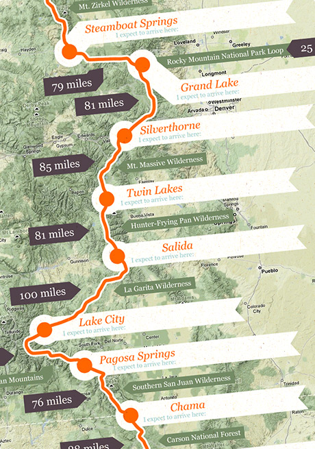
Imade this map of the CDT split into each section with basic info like how far it was in between towns, what I thought our daily mileage would be based on the terrain and estimated date we’d be getting to each place. We found it incredibly useful to visualise an overview of the route ahead and get a quick mental summary of the next state etc.
I hope that someone planning their future CDT hike will find this post and find the maps useful. I’ve made 2 new version for you to download (both zipped files contain a jpeg & pdf version):
- First map – with blank labels for you to print out and write in your eta.
- Second map – with the our actual daily mileages and dates that we walked the CDT to use as reference. (I’ve fudged a few figures to make it more consistent). I would say that our pace was fairly ‘average’ our target was 20 miles a day, which seems to be most peoples target.
For more more info on our hike, see our ‘proof that we actually did it’ site here »
Oh and of course the base map is courtesy of Monsieur Google (his terrain view is kick-ass).
Liked the map so much that we used it for a nice visual way of showing our planned walk on the CDT in 2009. Made some mods to the map to cover the Big Sky cut off that we did between Butte Montana and Yellowstone. Thanks for that great resource Cookie and loved looking through the imaginative website!
brian, black isle, scotland
Cheers Sam :)
Oh, and Benny Hill would be proud of your video as well.
Gorgeous map work. The site itself is very nice looking as well.
Cheers Joker :) been checking out your blog, awesome photos man! Yeah highly recommend the CDT, I’m currently trying to work out how I could fit the PCT in a year or two.
Hey man, awesome blog. Watched your CDT videos, they’re super inspiring. I hiked the PCT in 08, looking at possibly CDT this year in 09. Thanks for the resources!